Monday 28 September 2020

'Ip 'Ip LeJog : Day 5 - Topley Pike to Rushup Edge

A brilliant day's weather for the latest leg of our jaunt - the winds had finally abated & we were down to shirtsleeves soon after climbing out of Chee Dale!

I had said that we could stick with The Pennine Bridleway for quite a long distance but, of course, when it came to it, I had to slip in a few detours! The diversions, however, did make the walk a bit more special as we wandered along paths that I'd never walked before... always a good aim in such a venture!

Another feature of today's walk was that rather than just following paths & lanes to our destination we managed to slip in a few 'vias'... so we headed for Rushup Edge via Wormhill, Peak Forest, Old Dam & Perryfoot!


Started the day by dropping down from Topley Pike lay-by, high up on the A6, to Chee Dale on 'The Monsal Trail': another former railway line reinvented as a cycle trail running all the way to Bakewell.
This was a section of the Manchester, Buxton, Matlock & Midlands Junction Railway built in 1863 to link Manchester with London. The line closed in 1968 & was taken over by the National Park in 1980.
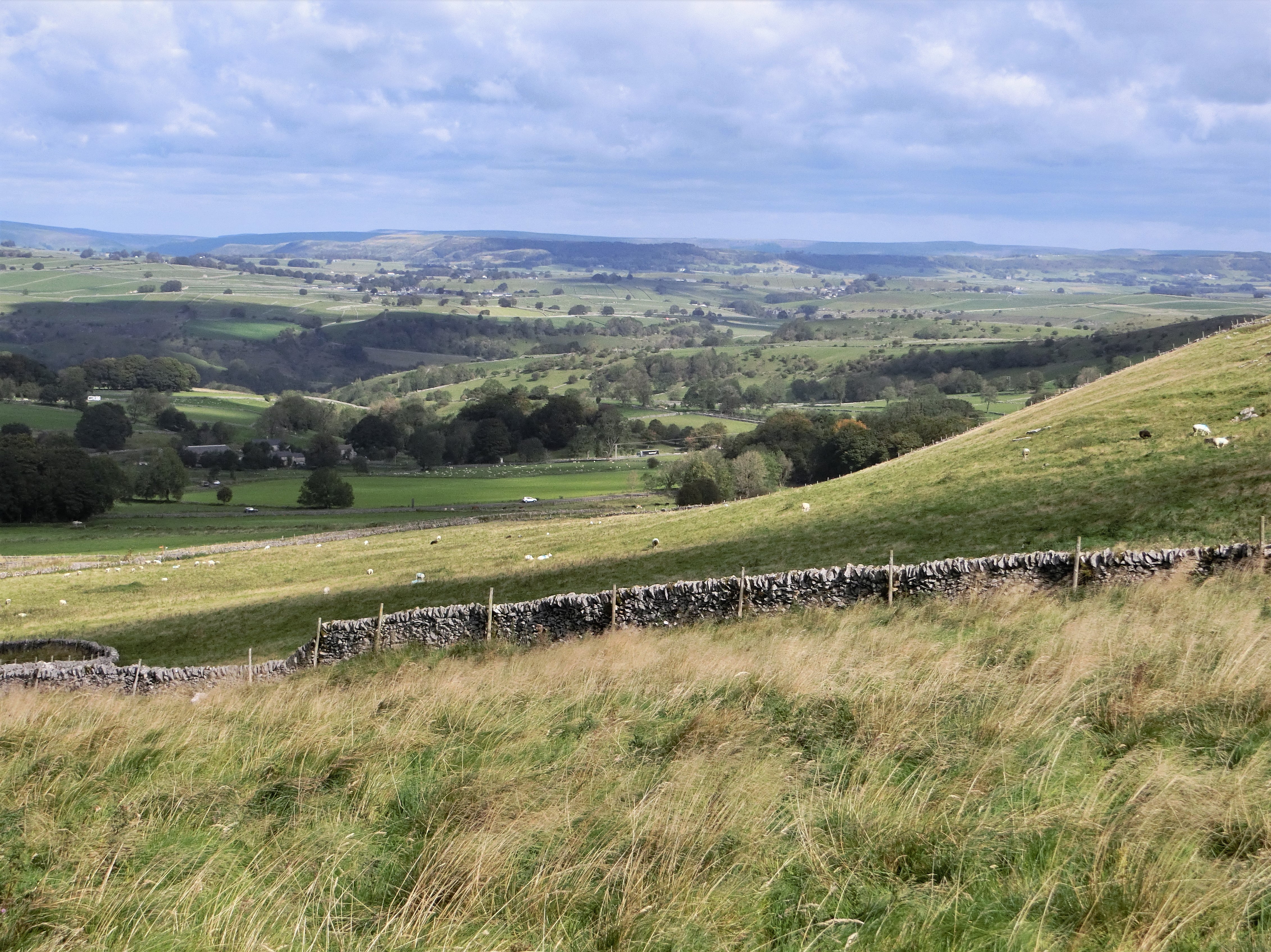

Chee Dale
The cycle/walking trail is famous for its spectacular scenery, its magnificent viaduct & its eerily lengthy tunnels, which were finally reopened in 2011!!


Blackwell Mill Halt Railway Cottages
Derelict & unoccupied in the 1970s, this row of eight terraced cottages built for railway-workers over a hundred years earlier are now looking quite magnificent!
Home to yet another cycle-hire business!


Climbing out of Chee Dale
This spectacular railway was only built along the Wye Valley because the Duke of Devonshire refused to allow it to desecrate Chatsworth!
Not a popular decision with poet & Conservationist, John Ruskin!

"There was a rocky valley between Buxton and Bakewell, once upon a time, divine as the Vale of Tempe... You Enterprised a Railroad through the valley – you blasted its rocks away, heaped thousands of tons of shale into its lovely stream. The valley is gone, and the Gods with it; and now, every fool in Buxton can be in Bakewell in half an hour, and every fool in Bakewell at Buxton; which you think a lucrative process of exchange – you Fools everywhere."

Words that can be found on Headstone Viaduct at Monsal Head, designated a Grade 2 listed building in 1970!


Blackwell Mill Halt from above &, yes, there was once a mill here - probably as early as 1066!
Our car is parked in the lay-by at the top of the picture... which is why it was time to shed jackets!


Entrance to Mosley Farm at the top of the climb, a friend for Eeyore & a chance to get our breath back!


James Brindley Well, Wormhill
We followed 'The Pennine Bridleway' around the top of the quarry towards the hamlet of Tunstead which, presumably, gave the quarry its name before heading through stone-walled fields to the village of Wormhill.
Tunstead Quarry may well be the largest in Europe but the hamlet is far better known as the birthplace of canal-builder James Brindley!


We'll have more to do with Brindley later, including on our first 'Southern Leg' of this trek when we will head south-east along his Caldon Canal.
Intriguingly, our closest connection with Brindley is through our local pub in Ipstones: it is alleged that he died a couple of days after spending a night at 'The Old Red Lion'. Some versions suggest that he slept in a damp bed, some that the landlord refused to light a fire, some that he'd fallen in his canal earlier that day... more realistically he was seriously ill with Diabetes.
Whatever the truth, he was here & died shortly afterwards!


Church of St Margaret of Antioch, Wormhill
Of course we had to wander around the village despite the fact that we have often visited for their well-dressings! There were two 'new' geocaches that we needed to visit!
I love the 'saddleback' roof on the unusually-shaped tower & there is, apparently, only one other in the country... but nobody's telling me where it is!
I'll just have to keep on walking!


Wormhill Stocks
I can't believe that the little one on the left is guilty!
This was once great wolf-hunting territory & the last wolf in England was reputedly killed at Wormhill Hall in the 15th century...


Peter Dale
Time for one of those diversions along paths untravelled!
Diverted from The Pennine Bridleway to follow The Limestone Way through Peter Dale... an excellent shortcut!


Dale Head
The point at which Peter Dale becomes Hay Dale... even though it's all part of one long dry valley!
Decided to continue straight along here & then into Dam Dale, shunning both The Limestone Way & The Pennine Bridleway on our direct route to the village of Peak Forest!
Had intended to stop at the pub in Peak Forest given its advertised opening times, supported by chalk-boards outside, & given the fact that I've sat in their garden before.
All closed... so had a sandwich & a can of cider on the bench opposite both pub & the unusually large church dedicated to Charles, King & Martyr.
Even more unusually, until 1754, the Minister here was able to perform marriages without 'reading the Banns' - a Derbyshire elopement hot-spot!


Rebellion over & we rejoined The Pennine Bridleway for the rest of our walk.
This spot is at the northern end of Perry Dale, just before Perryfoot. You can see from the sheep that it had turned into a very warm afternoon!


Rushup Edge from Perryfoot
Now, to anyone else, this may seem quite an insignificant photo but the van was parked on top of that hill & it was all upwards from here!
Even more significantly this was to be the first time our current route would meet the 2011 LeJog route! I walked along Rushup Edge on Friday 10th June 2011, aiming for Edale where, the next day, we would begin The Pennine Way... walking with Jamie, Kirstie & Andy!


Pretty good place to finish! That's our next day northwards, heading towards South Head & Mount Famine... love the name!

Today's distance : 11.00 miles        17.71 kilometres

Cumulative : 44.03 miles        70.88 kilometres

Direction of Travel : North

Progress : We are now 370.07 miles from John o' Groats (-6.29 miles)!
& 280.18 miles from Land's End (+4.03 miles)!


Friday 25 September 2020

'Ip 'Ip LeJog : Day 4 - Parsley Hay to Topley Pike

Yet more coronavirus restrictions introduced almost all around our Moorlands setting is beginning to make plotting a route quite tricky!

Finally abandoned the idea of using 'The Midshires Way' to head up to Whaley Bridge & The Peak Forest Canal, deciding it would be too busy a route & would take us quite close to Manchester.

Opted to stick with The Pennine Bridleway which we might be able to follow for quite some distance, currently skirting newly-restricted areas!

Managed to choose a bright & sunny day though you'll be able to see from our jackets that it was cold! Commented last time about the wind... even windier today - when we got home a bin was pirouetting in the driveway & a water butt had blown over!

Parsley Hay
The name is now synonymous with bike hire but this was one of the original stations on the High Peak Goods' Line, closed in 1877 but reopened in 1894 when the passenger line opened.


Similar photo to one from the last walk but this one clearly showing the end of the High Peak Trail at Dowlow, today's first waymark!


See the jackets... & the sweatshirt! Chilly weather!
Already aware that this old railway jaunt was going to be much quieter... the weather,  the virus or the location?


Istrian Kazun from Croatia
Built by dry-stone masons from Istria using limestone from the nearby Once-a-Week quarry & sandstone from the Wellfield quarry near Huddersfield.
Common throughout Europe in places where dry-stone walling is used... often known as Beehive Huts in England & Scotland.


Plaque on the Kazun
In memory of a Civil Engineer from Zagreb who gained his PhD in Swansea & held a senior position at The University of Glasgow.


Pomeroy
Almost time for us to turn off & almost the end of the High Peak Trail.
Interestingly, Pomeroy is the start & finish point for Flagg Races, an annual point-to-point event which usually takes place just after Easter. In recent years it has been cancelled because of drought & snow... though wars and Foot & Mouth have occasionally been an issue!


Left The High Peak Trail now & heading over the tops to Chelmorton on The Pennine Bridleway.
Sensibly, the cows are sheltering behind the wall from the fierce wind!


Chelmorton
One of the highest villages in England, so hardly surprising it was so windy! Managed to tuck Eeyore into a little niche in the woodwork!
What's more surprising is that we didn't divert to the excellent 'Church Inn', a fine old pub first opened in 1742... but we've been there several times before & I was being lured by a chambered tomb!!


Five Wells Tomb
Reputedly, the highest megalithic tomb in Britain. A pity that its elaborate stone surroundings were removed more than 200 years ago... to build walls!


Splendid views towards Tideswell, Eyam & Shatton Edge as we dropped down The Pennine Bridleway to the remarkably quiet A6!


Tunstead Quarry
Slightly incongruous view!
Opened in 1929, by 1973 this was the largest quarry in Europe!
Permission to extend into The Peak District National Park was refused on the grounds that there was insufficient stone to last until 2000, a decision ultimately overridden by the Government. The quarry is still going strongly so, perhaps, some Government got something right!


Chee Dale
The start of our next walk... down to Blackwell Cottages & then up & on to Wormhill... we'll be exhausted after the first hour!!

Today's distance : 8.18 miles        13.17 kilometres

Cumulative : 33.03 miles        53.17 kilometres

Direction of Travel : North

Progress : We are now 376.36 miles from John o' Groats (-5.67 miles)!
& 276.15 miles from Land's End (+2.89 miles)!


Saturday 19 September 2020

'Ip 'Ip LeJog : Day 3 - Hulme End to Parsley Hay

Only a couple of days since our last jaunt on this project but, with more coronavirus restrictions looking imminent, we thought we'd better get a move on! Joined by daughter, Kirstie, & Jamie's Eeyore again on a fine, sunny if windy day!

Bit concerned that we might struggle to park at Hulme End as we hadn't realised today was Rubie's Walk day, an annual charity event along the Manifold Trail to raise money for meningitis. Fortunately, things were underway by the time we arrived, the walkers had set off & so it wasn't too busy!

Supposed to be Day 3 of the Northern leg but we set off in a south-easterly direction... just to take in the views!


All geared-up for today's socially-distanced adventure... pity it doesn't do anything for the focus!


Started off from the terminus of The Leek & Manifold Railway at Hulme End, the narrow-gauge line that we'd followed from Waterhouses. Both these photos were taken outside the Visitor Centre, formerly the ticket office!


Inside is this fine model of Hulme End station as it looked in 1934 when it was finally closed. The engine-shed in the foreground has been rebuilt & now houses 'The Tea Junction' cafe/restaurant.


Wolfscote Hill
There are at least half a dozen camping and/or caravanning sites in the area immediately around Hulme End but, after about a mile, civilization is left behind as a narrow cul-de-sac wends its way towards Beresford Dale, the River Dove & Wolfscote Hill.
The remains of a Neolithic Bowl Barrow can be picked out on top of the hill which, when excavated in the 1840s, was found to contain 2 child skeletons & a food vessel.


Crossing the River Dove & a thoughtful invitation on an enormous tree stump!


Frank i' th' Rocks cave at the Northern end of Wolfscote Dale
Its name can be found on the bridge over the Dove, just below the outcrop.


Here, too, was a Neolithic burial chamber, just around to the right in the first photo and not in the cave that Kirstie is sitting in!


Wolfscote Dale
Took a brief detour along Wolfscote Dale to discover a geocache high up the side of the gorge. This is the view southwards from the cache, along the Dove!


... &, only to be fair, this is the view northwards from the cache back to Beresford Dale!


Heathcote Mere
An unusual feature in this part of the Peak District - water that stays where it's put & doesn't go diving off through the limestone! That's because there's a layer of volcanic rock above the porous limestone here which has made the Mere an important watering-hole for centuries!
On a major packhorse route from East to West, fines were introduced as early as 1745 for anyone found to be polluting the water.


Hartington Station
We joined 'The Tissington Trail' at Heathcote, just along the lane from the Mere, & headed along the old railway route to Hartington Station... albeit 2 miles from the village!
Closed to regular passengers in 1954, its final closure came in 1963 when the buildings were demolished... apart from this wonderful Signal Box which was preserved as a Visitor Centre, still selling hot snacks & ice-creams despite the Covid-cones & warning signs!
Stopped for cider & ice-creams here - I'll let you guess who opted for what!


Majestic cutting on 'The Tissington Trail' just south of where the old Ashbourne to Buxton line meets the High Peak Trail.


And this is the point where the two old lines met... or parted company depending upon your direction of travel!


The line between Ashbourne & Buxton opened in 1899 & at its height of importance carried express trains between Manchester & London. Like 'The Leek & Manifold', its milk-trains were also essential running a daily service to London throughout World War 11.
It finally became a walking & cycle route in 1971, over 40 years after 'The Manifold Way'.


The High Peak Trail is older & much more famous!
It opened in 1831 & carried the Cromford & High Peak Railway from Cromford Canal to the Peak Forest Canal at Whaley Bridge, a distance of 33 miles. It climbed from 277feet above sea level to over 1000 feet at Ladmanlow before falling back to 517 feet at its terminus!
This was a Goods' line, though, carrying mainly corn, minerals & coal : it finally closed in 1967.


One last photo on the last bridge before Parsley Hay, a bike-hire centre so quite busy... but overall it was a gentle day!

Today's distance : 7.70 miles        12.40 kilometres

Cumulative : 24.85 miles        40.00 kilometres

Direction of Travel : North-East

Progress : We are now 382.03 miles from John o' Groats (-2.42 miles)!
& 273.26 miles from Land's End (+3.90 miles)!


Thursday 17 September 2020

'Ip 'Ip LeJog : Day 2 - Waterhouses to Hulme End

Haven't really been idling in the ten days since we started this adventure! Visited Lee in Lancaster & spent six days wandering  around the Trough of Bowland - mostly fine weather & some excellent walks!

Decided that using distances by road is, probably, not the best way of measuring progress so have decided to use a straight line distance to both John o' Groats & Land's End at the end of each walk. 

With the help of Ordnance Survey & my GPS I reckon it's 389.55 miles to John o' Groats from our home & 261.69 miles to Land's End! At the end of our first walk we were further away from both... so there's progress!!


The Manifold Light Railway was a narrow-gauge line opened in 1904 partly to transport minerals from the lead & copper mines around Ecton but, more importantly, to carry milk from the farms up the Manifold Valley to the standard-gauge branchline at Waterhouses which then opened up a direct route to London!


The tiny railway also provided a passenger service for the villages along the valley.

"Two little steam locomotives built to an Indian design and fitted with large headlamps pulled a series of narrow primrose-painted carriages with tiny verandas. What a curious sight this must have been if seen from the surrounding hilltops."

A slump in mineral prices & a switch to road transport led to the line's closure in 1934 - it was reopened as a footpath & cycle-track in 1937, pre-dating Sustrans by exactly 40 years!


Setting off from the former Waterhouses station, in front of the Silver Jubilee cairn & seat. Quite breezy here... but we were soon down to shirtsleeves!


Beeston Tor & the site of one of the line's stations. The wooden building is the original refreshment room, now nestled at the edge of a camp-site!
Took a slight uphill detour here to pick up 'Weags Barn' geocache!


There have been a lot of people complaining that we've had a wet Summer... so where's the River Manifold gone?!
Just one of those peculiarities of Limestone country... it keeps diving down holes but it'll be back!


Trying to get a decent view of Thor's Cave through the trees & without the sun intervening!
Just above is the village of Wetton, famous for its annual toe-wrestling competition... in non-Covid times!


A reasonably straightforward walk up to the cave but we've done it before (from the top & the bottom), it had become very warm & we were ready for refreshment!


Thor's Cave in the sunshine!


Wetton Mill
There was once a station here & a waiting-room!
Look! The river has returned! It disappears just south of this point!


Here was my longed-for refreshment but it wasn't easy keeping it from the ducks!
Les had hoped for an ice-cream but, with only 2 customers allowed in the shop, there was quite a sizeable socially-distanced queue outside... which hadn't totally disappeared by the time we moved on.


The mill buildings are just to the right of this photo & are now used as a holiday-cottage.
Wetton Mill was a watermill for grinding corn : it closed in 1857, long before the railway arrived!


Entrance to the Swainsley Copper Mine, now behind a locked gate & partially blocked by a landslip/mudslide.
I'd been tempted to venture inside on my first visit here in 2013!


Swainsley Tunnel
Built by Sir Thomas Wardle who, though a shareholder in the railway, didn't want to see it cross his land!
During World War II, after the line's closure, the tunnel was used by the RAF for munitions storage &, in more recent lockdown-days, it's been used as a meeting-place for boy-racers! Signs warn against that now!!


And so, finally, to 'The Manifold Inn', more refreshment & the end of our walk!
Built as a coaching inn, this was originally 'The Waggon & Horses' & the old stables & outhouses are now used as hotel accommodation.
It became 'The Old Light Railway Hotel' before changing name again & now even the old Thor's Cave sign has been removed!

Today's distance : 9.81 miles            15.79 kilometres

Cumulative : 17.15 miles            27.6 kilometres

Direction of Travel : North

Progress : We are now 384.45 miles from John o' Groats (-5.49 miles)!
& 269.36 miles from Land's End (+5.01 miles)!