A brilliant day's weather for the latest leg of our jaunt - the winds had finally abated & we were down to shirtsleeves soon after climbing out of Chee Dale!
I had said that we could stick with The Pennine Bridleway for quite a long distance but, of course, when it came to it, I had to slip in a few detours! The diversions, however, did make the walk a bit more special as we wandered along paths that I'd never walked before... always a good aim in such a venture!
Another feature of today's walk was that rather than just following paths & lanes to our destination we managed to slip in a few 'vias'... so we headed for Rushup Edge via Wormhill, Peak Forest, Old Dam & Perryfoot!
Started the day by dropping down from Topley Pike lay-by, high up on the A6, to Chee Dale on 'The Monsal Trail': another former railway line reinvented as a cycle trail running all the way to Bakewell.
This was a section of the Manchester, Buxton, Matlock & Midlands Junction Railway built in 1863 to link Manchester with London. The line closed in 1968 & was taken over by the National Park in 1980.
Chee Dale
The cycle/walking trail is famous for its spectacular scenery, its magnificent viaduct & its eerily lengthy tunnels, which were finally reopened in 2011!!
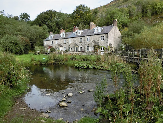
Blackwell Mill Halt Railway Cottages
Derelict & unoccupied in the 1970s, this row of eight terraced cottages built for railway-workers over a hundred years earlier are now looking quite magnificent!
Home to yet another cycle-hire business!
Climbing out of Chee Dale
This spectacular railway was only built along the Wye Valley because the Duke of Devonshire refused to allow it to desecrate Chatsworth!
Not a popular decision with poet & Conservationist, John Ruskin!
"There was a rocky valley between Buxton and Bakewell, once upon a time, divine as the Vale of Tempe... You Enterprised a Railroad through the valley – you blasted its rocks away, heaped thousands of tons of shale into its lovely stream. The valley is gone, and the Gods with it; and now, every fool in Buxton can be in Bakewell in half an hour, and every fool in Bakewell at Buxton; which you think a lucrative process of exchange – you Fools everywhere."
Words that can be found on Headstone Viaduct at Monsal Head, designated a Grade 2 listed building in 1970!
Blackwell Mill Halt from above &, yes, there was once a mill here - probably as early as 1066!
Our car is parked in the lay-by at the top of the picture... which is why it was time to shed jackets!
Entrance to Mosley Farm at the top of the climb, a friend for Eeyore & a chance to get our breath back!
James Brindley Well, Wormhill
We followed 'The Pennine Bridleway' around the top of the quarry towards the hamlet of Tunstead which, presumably, gave the quarry its name before heading through stone-walled fields to the village of Wormhill.
Tunstead Quarry may well be the largest in Europe but the hamlet is far better known as the birthplace of canal-builder James Brindley!
We'll have more to do with Brindley later, including on our first 'Southern Leg' of this trek when we will head south-east along his Caldon Canal.
Intriguingly, our closest connection with Brindley is through our local pub in Ipstones: it is alleged that he died a couple of days after spending a night at 'The Old Red Lion'. Some versions suggest that he slept in a damp bed, some that the landlord refused to light a fire, some that he'd fallen in his canal earlier that day... more realistically he was seriously ill with Diabetes.
Whatever the truth, he was here & died shortly afterwards!
Church of St Margaret of Antioch, Wormhill
Of course we had to wander around the village despite the fact that we have often visited for their well-dressings! There were two 'new' geocaches that we needed to visit!
I love the 'saddleback' roof on the unusually-shaped tower & there is, apparently, only one other in the country... but nobody's telling me where it is!
I'll just have to keep on walking!
I can't believe that the little one on the left is guilty!
This was once great wolf-hunting territory & the last wolf in England was reputedly killed at Wormhill Hall in the 15th century...
Peter Dale
Time for one of those diversions along paths untravelled!
Diverted from The Pennine Bridleway to follow The Limestone Way through Peter Dale... an excellent shortcut!
Dale Head
The point at which Peter Dale becomes Hay Dale... even though it's all part of one long dry valley!
Decided to continue straight along here & then into Dam Dale, shunning both The Limestone Way & The Pennine Bridleway on our direct route to the village of Peak Forest!
Had intended to stop at the pub in Peak Forest given its advertised opening times, supported by chalk-boards outside, & given the fact that I've sat in their garden before.
All closed... so had a sandwich & a can of cider on the bench opposite both pub & the unusually large church dedicated to Charles, King & Martyr.
Even more unusually, until 1754, the Minister here was able to perform marriages without 'reading the Banns' - a Derbyshire elopement hot-spot!
Rebellion over & we rejoined The Pennine Bridleway for the rest of our walk.
This spot is at the northern end of Perry Dale, just before Perryfoot. You can see from the sheep that it had turned into a very warm afternoon!
Now, to anyone else, this may seem quite an insignificant photo but the van was parked on top of that hill & it was all upwards from here!
Even more significantly this was to be the first time our current route would meet the 2011 LeJog route! I walked along Rushup Edge on Friday 10th June 2011, aiming for Edale where, the next day, we would begin The Pennine Way... walking with Jamie, Kirstie & Andy!
Pretty good place to finish! That's our next day northwards, heading towards South Head & Mount Famine... love the name!
Today's distance : 11.00 miles 17.71 kilometres
Cumulative : 44.03 miles 70.88 kilometres
Direction of Travel : North
Progress : We are now 370.07 miles from John o' Groats (-6.29 miles)!
& 280.18 miles from Land's End (+4.03 miles)!


No comments:
Post a Comment