A fine morning but with heavy rain forecast for the afternoon we decided to slot in this comparatively short stretch, via Denstone, & see if we could beat the weather!
It all worked out perfectly! The later photos show the fine sunshine in Rocester when we finished. Dark clouds were rumbling towards Alton when we picked up the van &, thirty minutes later, upon reaching home, Ipstones was awash! Five minutes after this & it had eased enough for me to wander down to 'The Marquis of Granby' for a pint & to order Friday night fish & chips!
Sadly, the mileages went a little awry as we continued in a south-easterly direction still following The Churnet Way & bits of The Staffordshire Way - finished further away from both Land's End & John O' Groats!
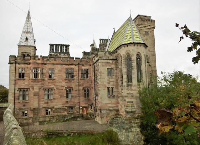
Started off by picking up a nearby Church Micro geocache left over from the other day before the promised closer look at Alton Castle.
Pugin's castle is the third to occupy this hill-top site with its commanding view over the Churnet Valley.
The first was an 8th century Anglo-Saxon fortification while the remains of the second can be seen on the left of the photo. This was built in the 12th century & was typically Norman with several towers linked by curtain walls.
The castle came into the possession of the Earls of Shrewsbury through marriage in the early 15th century but, unfortunately, they backed the wrong side in the Civil War & Cromwell made sure it could no longer operate as an effective stronghold!
And so to the 16th Earl who commissioned Pugin to demolish the old castle & create a "new building which was designed to look like a medieval castle built by English crusaders of the Knights of the Teutonic Order in Germany."
Pugin was already working on Alton Towers, the Earl's family-home, so this seems like a bit of an elaborate folly!
The castle has spent much of its working-life as convent, boarding-school, Catholic Youth Retreat & wedding-venue... at the moment it just looks a bit neglected.

The Staffordshire Way again chooses the high ground out of Alton, along an old saltway unimaginatively named Saltersford Lane but we took the lower route purely to take this photo!
In 2014 replacement mileposts were cast to mark the original route of the Uttoxeter Canal (see Day 6) & I love that these replicas stand alongside the cycle-track/footpath & former railway!
Denstone Station
Just about as far as you can follow the old railway & canal route.
Originally there was no station here but this was built when Denstone College opened in 1873 as a Christian boarding-school for boys.
Nothing at the station now except sheltered picnic tables & a few children's playthings provided by Burton Breweries.
Memorial Fountain, Denstone
Erected in 1900 to the memory of Sir Thomas Percival Heywood, a Manchester banker who moved to the area in 1846 - an area known, locally, as Denstone-in-the-Dirt!
He set about developing the village & creating a Parish. All Saints' Church was opened in 1862, the village school in 1870 whilst he was also co-founder of Denstone College with Nathaniel Woodward.
The fountain is still fed by a spring & reservoir which, originally, also provided piped water to roadside taps & to some of the houses in the village.
Sir Thomas' Village school was eventually replaced by All Saints First School in 1998 & we passed it just a little further along Oak Road.
Love the Covid posters on their gates!
"... a creature with terrible claws, and terrible tusks in its terrible jaws, and knobbly knees and turned-out toes, and a poisonous wart at the end of its nose."
Thanks, Julia Donaldson - what else can I say?!
This is mostly why we ran out of canal, railway & cycle-track! JCB World Headquarters!
Founded by Joseph Cyril Bamford in 1945, he began his business in a rented lock-up garage in Uttoxeter.
According to the company, they currently "have 22 plants on four continents and more than 750 dealers around the world."
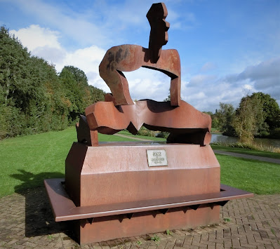
Startled Horse by Mark Delf
Finished today's walk with a wander around the JCB Lake, certainly my favourite thing about the site!
A variety of interesting sculptures, this one by a Staffordshire artist.
Sumo by Allen Jones
Managed to find our second cache of the day here!
And, finally, Opus : another by Mark Delf
I presume Lord Bamford likes this one as his machinery makes this kind of work so much easier!
Time to head over the road & into the village of Rocester...
Today's distance : 5.88 miles 9.46 kilometres
Cumulative : 61.11 miles 98.36 kilometres
Direction of Travel : South-East!
Progress : We are now 396.76 miles from John o' Groats (+1.87 miles)!
& 260.19 miles from Land's End (+0.17 miles)!

